Mountaineers have always adored Mt. Washington. Despite not being as popular as Mt. Everest, Mt. Olympus, or Kilimanjaro, its macabre beauty and extreme weather conditions sometimes surpass those of its rivals. Mountaineers can’t wait to get to the summit of any Mountain they see, and this one is no different. There are quite a few ways to visit its peak.
You can visit Mt. Washington’s peak by car, van, train, hiking, snow Van or online. Among these six methods, car drive, train, and hiking are the most popular. You can get direct guidelines about these three from Mt. Washington’s website.
In this guide, I will describe all the 6 ways to visit the summit of Mt. Washington NH in detail. I will also give you some insights about any difficulty you might face on your way and about any precautions that are advised. Whether you are a beginner mountaineer or conquered several peaks already, this guide has got something for everyone.
Heading to the Summit of Mt. Washington NH
In this part of the article, I will talk about all the six ways you have to visit the peak of Mt. Washington. I will talk about the three most popular methods first, then the rest three. Let’s get right into it:
1. Hiking
There’s a certain group of people who love hiking. Hiking offers the most challenging path to conquering the peak of any mountain, and that’s what they want. Fortunate for them, authorities allow hiking Mt. Washington despite being the smallest dangerous mountain in the world. Mt. Washington has quite a few hiking trails.
There are five most commonly used hiking trails to go to the top. They are Tuckerman Ravine Trail, Lion’s Head Trail, Ammonoosuc Trail, Jewell Trail, and the Boott Spur Trail. There are other minor and insignificant trails as well. Those trails are often used by Bonafide hikers. But if you are not local, these five trails are the ones to consider.
Tuckerman Ravine Trail: Each of the trails has a different approach with different scenic views and varying difficulty. Tuckerman Ravine Trail is one of the two shortest routes to the top of the mountain peak. It starts from Pinkham notch and is approximately 4.2 miles long. However, this trail is extremely punishing for any mountaineers, from beginner to expert.
Lion’s Head Trail: The second of the two shortest routes is the Lion’s Head Trail. It also starts from Pinkham notch and 4.2 miles long. Where it differs from the Tuckerman Ravine is the steepness. It’s steeper than the Tuckerman Ravine and the terrain is more rough and uneven. These two trails are ill-advised for any beginner mountaineer as the path is extremely craggy and bumpy.
Ammonoosuc Trail: The Ammonoosuc Trail starts from the cog railway station and it can be paired with the Jewell Trail for a good loop hike. It is 4.5 miles long and fairly rough. But it offers a very scenic route. You can visit the AMC Lakes of the Clouds Hut via this route. For anyone who wants to savor a picturesque and challenging route, the Ammonoosuc Trail is for you.
Jewell Trail: The Jewell Trail is the easiest route to the top of the mountain. It also starts from the cog railway station and is about 5.2 miles long. It has the least elevation than any other trail on this list, around 4000 feet. But don’t let that fool you as the path is pretty grueling and laborious. It’s a mixture of both toughness and ease, making it suitable for beginners.
Boott Spurr Trail: The Boott Spurr Trail is 5.2 miles long and more elevated than the Tuckerman Ravine. Despite being longer and steeper, the path itself is surprisingly easier. It has great natural views to enjoy. You can make two loop hikes with the Tuckerman Ravine and Lions Head Trail. You can finish the loops within the daytime so if you don’t want to be there in the dark, Boott Spurr can be your pick.
I am not strictly advising against any of these. All of them are pretty decent hiking trails when the weather is good. As long as you are not a complete novice in trail hiking, you can take any of these paths.

2. Mt. Washington Auto Road
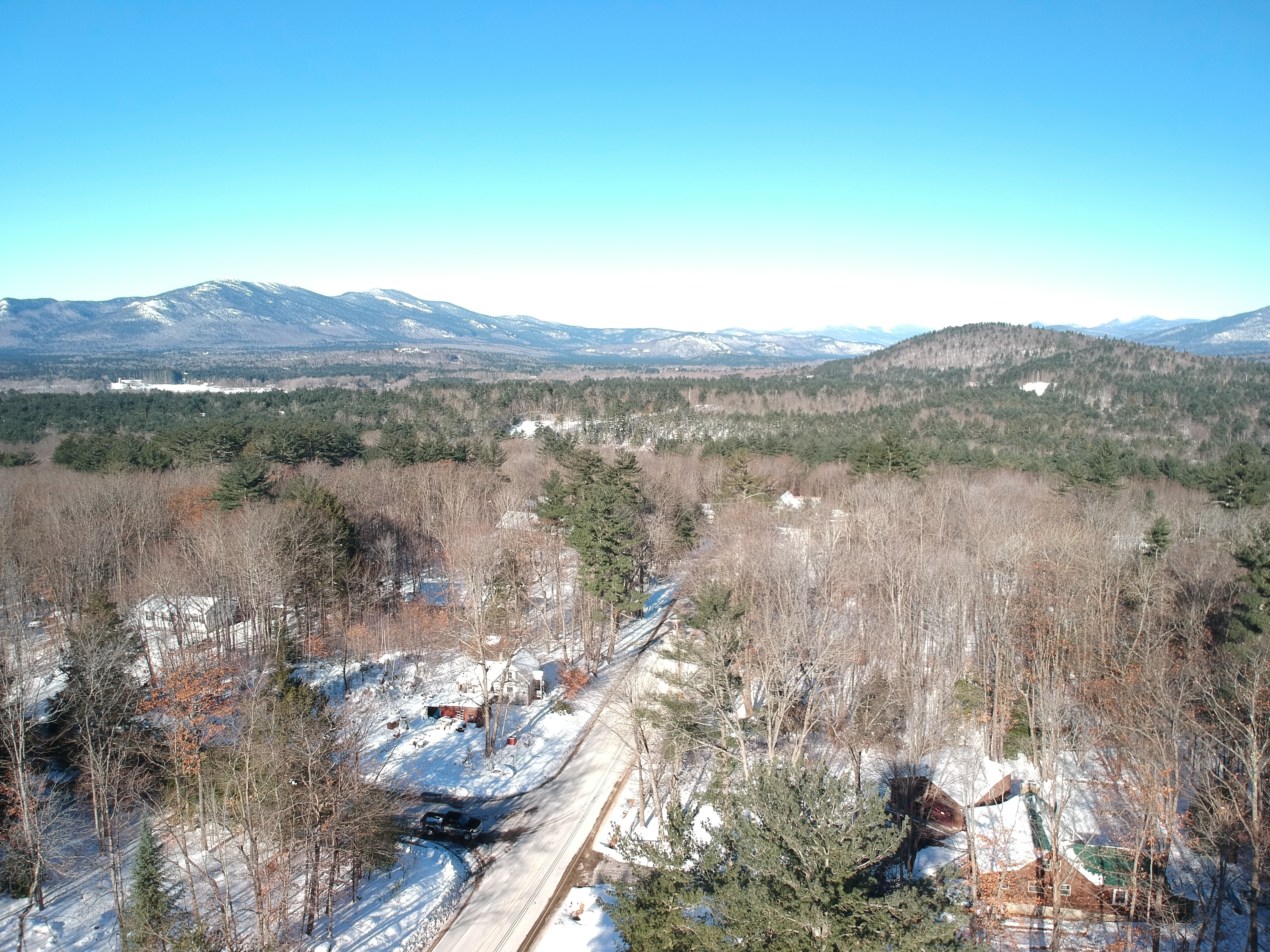
Americans love to drive. So, no wonder this mountain has some sort of driving route to its top. And guess what, the road, named Mt. Washington auto road was constructed back in 1861! It is located on New Hampshire route 16 and about 7.6 miles long. It has an elevation of 4600 feet from an altitude of 1527 feet from sea level.
The Mt. Washington auto road alone is used for three types of travel you can take. You can drive yourself by car or motorbike. Or you can be a part of the guided van tour where the driver will guide you through every page of history this road has to offer. During the winters, Mt. Washington SnowCoach also takes this path, traversing the snows to take you to the summit.
The road offers you a smooth drive with surrounding views that are not for the faint of hearts. Any slight miscalculation shall cause a death. If you have previous mountain driving experience, you can drive yourself here. Otherwise, there is a guided tour service where an experienced driver shall take the wheels.
Before you start your adventure, check the times of operation on their website. The road is closed in winters due to bad weather. No night driving is allowed for the safety of the travelers. You also don’t have to book any reservations before your journey. But I recommend avoiding tourist seasons as the traffic is horrible.
Check on their website if your vehicle is allowed to drive up there. Keep your credit card or cash with you for the toll house. Personal checks are not accepted. The drive usually takes 30 minutes to get to the top and about 45 minutes to drive back. Make sure you have enough fuel to drive back. If you are not experienced enough to drive on such roads, let someone else take the wheel.
If it’s your first time, I suggest downloading the Mt. Washington Auto Road App for a detailed guide about the route. It is available for both Android and iOS. If you are worried about driving safety, let me tell you that among 150 deaths, only 3 of them occurred on the Mt. Washington auto road and the latest one dates back to 2009.
So, what are you waiting for? Get in your car and fire up the engine!
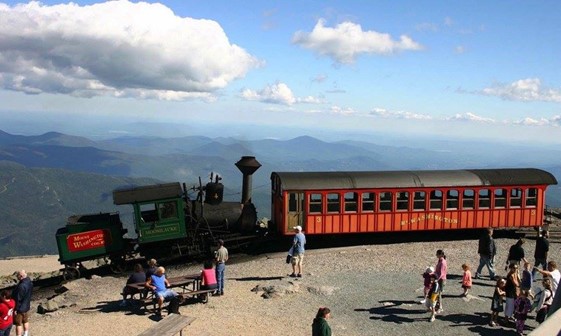
3. Mt. Washington Cog Railway
Railway is one of the oldest ways of transportation and traveling. But climbing to the mountaintop via train is something exceptional. This exceptional feat was achieved back in 1868. It’s the world’s first cog railway and the second steepest, after the Pilatus railway in Mt. Pilatus, Switzerland.
I’m sure you are wondering what a cog railway is. Let me soothe your curiosity. A cog railway is also known as rack railway, rack-and-pinion railway, or cogwheel railway. It is a specially designed rail track for climbing up steep paths where the train will revert backward on traditional rail tracks.
Rack rail lines have the rack installed in between the two lines. The coaches are fitted with a pinion in the middle between the wheelsets. The pinion makes mechanical bonding with the rack installed on the track. The rack and pinion mechanism allows the train to run on steep lines where the grade is less than 10%.
Steepness grade is the amount of vertical climb per 100 feet horizontal distance. 10 percent grade means that with every 100 feet horizontal movement, the train is gaining an elevation of 10 feet.
Check for schedules and ticket prices on their websites. Note that there are three different trips and only one of them goes to the summit. The trip to the summit may or may not be active depending on the weather condition. The duration, price, and destination of all three trips are different. So, know which one you want before booking.
Trips to the Waumbek station take roughly one hour. It is located at 3900 feet. The short stoppage at the Waumbek station offers the tourist a lot of refreshment. You can leave the train for a better view if the weather is clean. You can see as far as Quebec to the north and the state of Vermont to the west.
The trip to the skyline is further above from the Waumbek station. It is a place situated at 5500 feet and offers a spectacular view of the surroundings, surpassing the tree line. The trip takes about one hour and thirty minutes, including a 10 minutes stop at the skyline. During the return trip, you can get off the train at Waumbek station for taking photographs, etc.
The trip to the summit is a three-hour journey to a height of 6288 feet. You can visit the state park and take some excellent photographs. There are two types of trains to the summit; biodiesel engine and steam trains. If you want to get lost in history during this breathtaking journey, you can take the steam trains. That’s what they are for.

4. Mt. Washington SnowCoach
Mt. Washington is notorious for bad weather. During the winters, the entire mountain and hiking trails are covered in snow. The auto road remains completely shut down throughout the winter. Hiking to the summit in a snow-covered winter is a deadly Task. If you don’t have prior experience and a fit body, you won’t be permitted to climb the mountain.
So, what to do in the winter? The answer is Mt. Washington SnowCoach. It is a van where four triangular snow tracks replace the four wheels. It travels to the tree line at 4200 feet to give you an amazing view. It’s worth mentioning that there is no separate route for the SnowCoach. It travels via Mt. Washington Auto Road which is covered in snow during the winter.
So, if you have driven to the peak via Mt. Washington Auto Road during summer, the SnowCoach will not offer anything new. Just the same view covered in white snow. However, although the snow-covered surrounding area is nothing new, it still feels like uncharted territory. I can bet that you won’t be bored.
Reservation is recommended due to extremely high demand. If some tickets remain unsold, you can get the tickets on the day of the journey. The ticket price is 59 dollars for adults, 35 dollars for juveniles, and 20 dollars for infants. The price is subject to change at any time so check their website for the latest information.
It will take 90 minutes to reach the destination. After reaching, you will be allowed to exit the vehicle for a few minutes for site-seeing and photographing. The drivers are highly experienced so don’t worry about safety. The first trip leaves before dawn. If you want to witness the stunning beauty of the sunrise on the tree line, try booking the first trip.
There are lots of tourists throughout the day so the coaches need to maintain a tight schedule. Even if you are not able to enjoy the sunrise, you will still be able to see the enchanting beauty before the dawn.
5. Guided Van Tour
Mt. Washington guided van tour is a one-of-a-kind experience. You will experience something new at every precarious turn on the iconic Mt. Washington auto road. Mt. Washington is unlike any other mountains in the world, and so is the auto road. You will feel like being a part of history with every second you pass on this road.
Being the highest peak in the northeast paired with diverse weather, the guided van tour on Mt. Washington auto road is an exceptional experience. As you pass through the northern presidential range, you will get a glimpse of Mt. Madison and Mt. Adams, which is the second-highest peak in the northern presidential mountain range.
The guide is also the driver. He is a highly experienced driver as well as a historian. He will guide you every minute throughout the journey. You will experience different climate zones during the entire trip along with some historical places. The guide will explain everything to you as he drives up to the summit.
There are two packages; a two-hour guided tour and a three-hour guided tour. The three-hour tour gives you more time to explore the summit as well as every turn along the path. The Mt. Washington auto road is full of history, diverse wildlife, and geology. No time is enough to be a part of all these, but the three-hour tour definitely will give more opportunity for sure.
The three-hour tour allows you to disembark and explore the trails on foot. The tour may be subject to bad weather, fierce wind, or dense fog. Take all the necessary preparations like heavy clothing, appropriate footwear, etc. With the right preparations, the Mt. Washington guided van tour will be a once-in-a-lifetime experience.

6. Online Tour of the Summit and Mt. Washington
If you are unable to journey to the mountain top, or you are from another country, you can visit the mountain via a virtual tour. Webcams are placed in vantage points offering you the most detailed view of the mountain and views from the mountain summit. However, you will have to be a premium member of Mt. Washington Observatory to experience the virtual tours.
The webcams are divided into two groups. One group offers views from the mountain summit and the other group lets you enjoy panoramic views of the mountain itself. I will talk about both groups briefly to give you a hint of what you are going to experience if you choose to go virtual.
Views from Summit: Four webcams are providing tremendous views from the summit. They are: observation deck, north view, west view, and summit sign. The observation deck webcam offers a view from east to north-east looking over the Mt. Washington state park. Image of this cam is refreshed every five minutes, so you will always get the most recent view.
Remember I talked about the Northern Presidential Range earlier? The north view webcam gives you scenic vistas over the high mountains of the presidential range. You get to enjoy the peaks of Mt. Jefferson, Mt. Madison, and Mt. Adams. You can enjoy the sunrise, sunset, and time-lapse videos from this webcam as well.
The west view cam is placed at the window at the weather station of Mt. Washington summit. You get to see the stunning beauty of Mt. Lafayette through this cam. This webcam also looks as far as the town of Franconia and gives you a glimpse of the Bretton Wood Mountain Resort.
The summit sign webcam is placed at the roof of Mt. Washington state park Sherman Adams visitor center and looks directly to the observation tower and the summit sign.
Views of the Mountain: Four cams represent a striking view of the mountain itself. These cams are from Bretton Woods, Attitash, Wildcat, and Jackson. The famous latitude 44° restaurant at Bretton woods, this webcam lets you enjoy one of the most popular views of the mountain to the tourists.
The cam at Attitash is placed at the summit of the Attitash mountain resort and looks directly to the north at Mt. Washington as well as the presidential range. This perspective this cam offers is highly sought out by the tourist and is very charming to watch.
The wildcat webcam, as you might have already guessed, is placed at the top of the Wildcat mountain. You get to see from Pinkham notch to Mt. Washington as well as Tuckerman ravine through this cam. If you look closely, you will see the Huntington ravine on the right side.
The Jackson webcam is placed on a private property in Jackson, thanks to the cooperation of the landowner. This cam pictures the slope on the east side of Mt. Washington.
About Mt. Washington NH
Before you start your journey to conquer the peak of Mt. Washington, it’s always good to have some basic information. It gives you a heads up of what you are getting into. Let’s start:
History
This mountain is known to the native and aborigines for a long time. They used to call it by various names like Kodaak Wadjo, Agiocochook, Waumbik, etc. Explorer from Florence, Italy named Giovanni da Verrazzano is known to be the first to discover this mountain in 1524, although it’s been known to people long before that.
Darby Field from Europe is the first mountaineer to climb Mt. Washington in 1642. Activities surrounding the mountain were fairly quiet up until the 19th century. All the important structures like summit houses, hotels, and observatory were constructed during this time. With the construction of the Mt. Washington auto road, the tourist attraction started booming since the beginning of the 20th century.
Location
Mt. Washington is also known as Agiocochook by the natives. It is the highest peak in the northeast of the United states and is located in New Hampshire, east of the Mississippi River. This mountain belongs to the presidential range of the white mountains. About 60 acres of Mt. Washington state park surrounds the entire mountain.
This mountain has the world’s first cog railway. The train climbs to the mountaintop from the west while the ever-so-famous Mt. Washington auto road scurries to the summit from the east. It has several trails adored by the hikers. You can also visit the summit by SnowCoach, van tour, air, and even virtual tour.

Climate
Mt. Washington is notorious for its extreme climate and inclement weather. In 1934, the observatory recorded a wind speed of 231 miles per hour. This bad boy still holds the record for the highest wind speed that isn’t associated with any kind of storm. Several storm tracks converge on the mountain peak. It is one of the contributing factors to such weather.
Another reason is its location. It is at the dead center of the presidential range. All the air gets funneled up and flows across the summit at extreme speed. You will see plenty of warning signs all around the mountain. Since the late 1800, around 150 people have died on this mountain. Most of them died because of bad weather.
Tourist Attraction
Mt. Washington is a highly popular tourist attraction. Not only the mountain, but the surrounding area is also a great source of tourism. You can visit places like Mt. Washington state park, explore the Appalachian Trail and the Mt. Washington valley, etc. All of these places are exotic tourist spots. You can get a guided tour offered by many tourism companies in that locality.
Even if you don’t plan to climb the mountain, you can leg some distances on the Jewell trail to get a hint at the hiking experience. There is also a fruit garden called Hatch Orchard where you can pick ripe edible fruits directly from trees. This is truly a wonderful experience to have.
Some Interesting Facts About Mt. Washington NH
Mt. Washington is called the most dangerous among the smallest mountains. It exhibits diverse climates and intense weather. So, it’s nothing surprising that there are some astonishing fun facts about this wonder of nature. Here are some of those:
- All the mountains in the presidential range are named after US presidents like Mt. Washington, Mt. Jefferson, Mt. Madison, M.t Jackson, Mt. Eisenhower, etc. It is called the presidential range for a reason.
- The extreme weather of Mt. Washington is evident. The highest temperature ever recorded was 72 degrees Fahrenheit, and the lowest was –47 degrees.
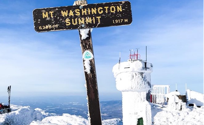
- Mt. Washington is the highest peak in the presidential range as well as in the northeast of the USA. Its summit is 6288 feet above sea level.
- On a clear day, you can see five states from the summit. They are New Hampshire, New York, Maine, Massachusetts, and Vermont
- The Mt. Washington observatory has never been deserted since 1932.
- The first-ever drive to the top dates back to August 31, 1899
- The world’s first-ever cog railway was built on this mountain in 1868 which is functional to this date.
Conclusion
Mt. Washington has been a fascination for mountaineers and tourists for many years. And it is one of those few mountains that offer full-fledged tourist facilities. Other than climbing the summit, it has other tourist attractions like Mt. Washington valley, Mt. Washington state forest, etc. The authorities have arranged several ways to get to the top of the mountain.
In this article, I have explicitly described the 6 ways to visit the summit of Mt. Washington NH. I discussed the major hiking trails. I also added some information about how you can enjoy the summit and its surroundings virtually, with some additional facts about the mountain. I am confident that this write-up will be enough to guide you to your best experience in Mt. Washington.